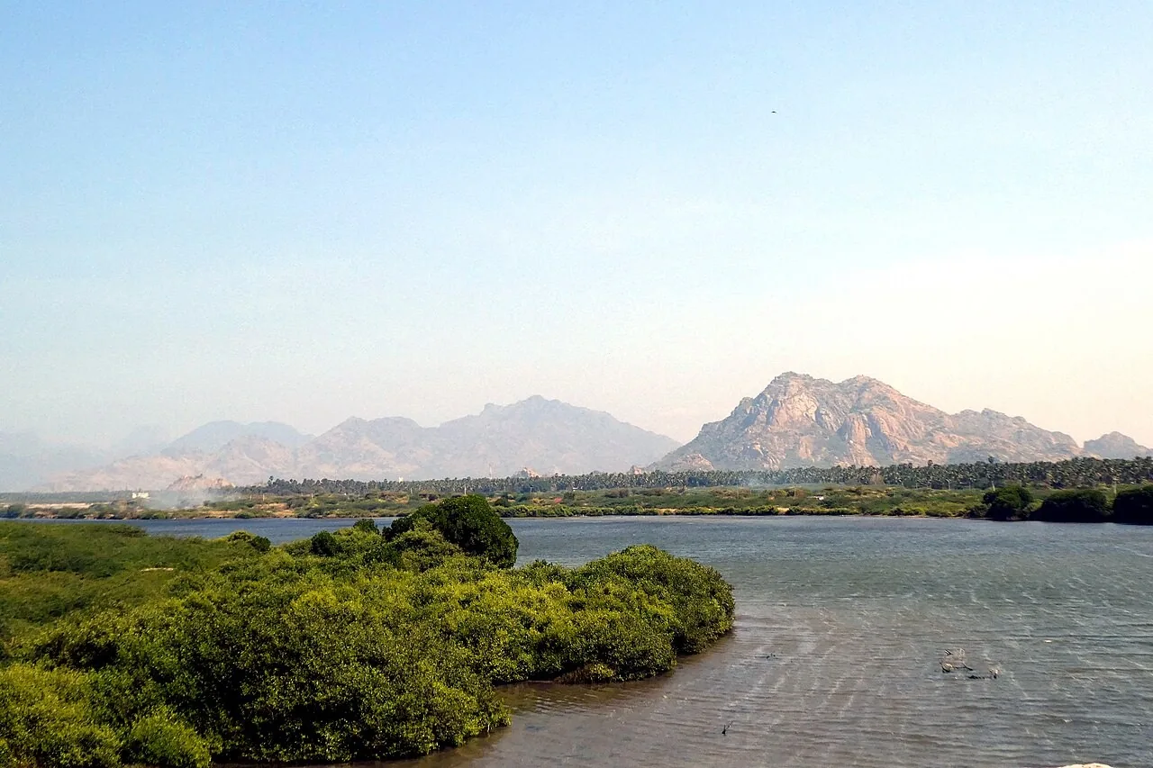

At a glance
- Location
- Manakudy, mouth of the Pazhayar on the southwest coast
- Recommended time
- 45–90 minutes for a quiet viewpoint stop
- Best for
- Nature observers, estuary landscapes and responsible coastal photography.
- Best time
- Choose daylight and calmer weather, with softer morning or evening light for observation. Tide, rainfall and river flow change the scene.
- Entry
- Confirm the particular viewpoint or public approach you intend to use; private land and working areas need permission. Visitor information should be confirmed before travelling.
- Walking
- Keep to stable public approaches and avoid mudflats, mangrove edges and steep or eroded banks.
Before you go: Do not swim or wade at the river mouth.
Visit durations are editorial planning suggestions. Allow extra time for travel, queues and your group’s pace.
Why visit Manakudy?
- The river-to-sea transition
- Mangroves and shallow-water habitat
- The seasonal pozhi sandbar and a working fishing coast
How to reach
By bus
The district estuary page lists 2J and 2L from Vadasery via Anna Bus Stand and Parakkai. It lists 2, 2J, 2K and 302 from Kanniyakumari via Kovalam. The Anna row says '37 Sector' without identifying a precise service. Confirm Manakudi and the safe public viewpoint before boarding.
By train
Nagercoil Junction (NCJ) is a regional rail gateway with a separate road journey to Manakudi. The nearest-station comparison and a station-to-estuary passenger connection were not established.
By road
Use the full Manakudi estuary locality and a confirmed public viewpoint. The district page places it near Kanniyakumari; do not assume that the bus goes to a safe river-mouth viewing area.
Official route listings checked: . District administration: Manakudi Estuary.
Checked the official web listing on 31 October 2026. This confirms what the authority publishes, not live operation. No departure times, frequency, fare or guaranteed return service verified. Confirm the destination, alighting stop and return service with bus staff. The Anna '37 Sector' label is not interpreted as an individual verified route number.
Visitor information
- Viewpoint and access
- Visitor information should be confirmed before travelling.
- Facilities
- No current visitor centre, toilets, parking arrangement or supervised water activity has been verified. Plan the stop around a confirmed public approach.
Best time to visit
Choose daylight and calmer weather, with softer morning or evening light for observation. Tide, rainfall and river flow change the scene.
Choose daylight and allow time to observe the water and birds. River flow, tides and the sandbar change the scene. Use only viewpoints with safe pedestrian space and keep clear of the river mouth and fishing access.
Visitor information should be confirmed before travelling. Fees, permissions, facilities and last entry are not established unless explicitly sourced below.
Facilities, parking and accessibility
Confirm toilets, drinking water, parking, step-free access and assistance with the destination. A railway or bus arrival does not establish access to the entrance; plan any final walk or transfer for your group.
Earlier visitor notes
Background notes: current arrangements require confirmation. Use the dated official source record for the scope of verified details.
Choose a public viewpoint
Use an established public approach and follow current local instructions. River mouths can have strong flows and changing ground; a photograph of someone standing near the water does not establish a safe route.
Pair an estuary view with another coastal stop if the day allows. Leave room to observe the place rather than planning a series of very brief beach visits.
What to see and do
- Begin at an established public viewpoint
- Observe the river, mangrove margin and sea as different habitats
- Leave space for fishing work and return without crossing the sandbar
Important things to know before visiting
Do not swim or wade at the river mouth. Currents, depth and footing can change; keep back from unprotected edges and do not stop on a traffic bridge.
Best way to experience this place
For nature lovers, spend time observing from one stable viewpoint with binoculars. Keep boats, nets and local work routes clear.
History and story behind the place
The bridge view includes a working coast
The estuary belongs to a lived landscape. Fishing equipment, boats, access paths and nearby settlements reveal how people use the coast and river mouth. Those activities can operate on different rhythms from sightseeing: weather, tides and fishing work determine when a place is busy and what space is needed.
A public viewpoint makes it possible to observe several layers at once. Look for the direction of moving water, the difference between a sheltered edge and exposed surf, and the relationship between boat access and the river opening. The contrast with an open beach such as Sanguthurai is instructive. Both are coastal stops, but only the estuary brings the river's drainage network directly into the scene.
Waste entering upstream and changes to the river mouth can affect the same habitat in different ways. Protecting Manakudy means attending to that whole relationship between river flow, marine processes, habitat and coastal work. The river mouth depends on connections that extend far beyond the shoreline visible from its bridge.
A place of everyday work
The surrounding coast is part of local livelihoods. Give space to fishing activity and avoid leaving litter near channels or mangrove vegetation.
Bird observation is most useful when a note records the date, location and conditions. An isolated sighting should not become a promise that every visitor will see the same species.
Geography, water and local life
A river does not end at a line
The lower Pazhayar connects the agricultural and urban landscape inland with the coast at Manakudy, also written Manakkudy. The river story follows that wider connection.
An estuary responds to freshwater flow, tides and the movement of sand. A view made in one season may look different after heavy rain or a change in the river mouth.
Why the river mouth changes through a day and a season
Manakudy is a meeting between the Pazhayar's freshwater flow and a coast influenced by tides, waves and moving sand. The water in that meeting zone is not one fixed mixture. More river flow pushes freshwater towards the sea; incoming tidal water can move saline water inland. Conditions can differ between a point near the mouth and one farther into the estuary.
Sand at the mouth is part of this movement. Coastal waves redistribute sediment while the river carries water and material from inland. A bar or opening visible during one visit is a stage in an ongoing process, rather than the permanent shape of the river's end. Photographs taken in different seasons can therefore show strikingly different arrangements without either being inaccurate.
These changes influence which habitats are wet, how water circulates and where fine sediment settles. The estuary is a transition zone with its own character, rather than simply the last short stretch of an inland river. Reading it in this way connects the view to the Pazhayar's cultivated and urban catchment.
Mangroves are part of a larger food web
Mangroves occupy an unusual boundary where wet ground, tidal influence and salt shape plant growth. Their roots and fallen material create structure and organic inputs around the water's edge. Small organisms use this structure, and larger animals feed on them. The habitat's importance therefore includes less conspicuous life in mud and water, alongside the birds visible above it.
Research on Manakudy has examined its fish assemblages and estuarine vegetation, while nutrient studies have investigated differences associated with human activity. Such studies help explain the relationships between habitat and water conditions. They do not establish that the entire estuary has identical water quality or that any single planted patch represents a fully restored ecosystem.
An estuary also includes exposed mud, channels, open water and sand. Protecting only trees while losing tidal connections or degrading adjacent water can leave the wider system impaired. The useful conservation question is how these parts work together. Mangrove cover is valuable, but its presence should not be used as a shortcut for judging every ecological process at the river mouth.
Three zones within one estuary
A Journal of Fisheries study published in 2026 followed Manakudy through monthly surveys from August 2023 to July 2025. Its sampling design makes the estuary's internal variation clear: one station represented the freshwater inflow, another the middle mangrove area, and a third the mouth where marine influence was stronger. A single photograph or water sample would capture only part of that sequence.
The study records grey mangrove, Avicennia marina, among the estuarine vegetation. Its species table also distinguishes animals recorded across all three stations from those recorded only towards the middle and mouth. For example, spotted snakehead was recorded at the freshwater and middle stations, whereas several ponyfishes were recorded at the middle and mouth stations. These are observations over a sampling period, but they make the habitat gradient tangible.
Seeing the estuary as linked zones changes the meaning of a coastal stop. The river mouth is not a separate attraction detached from its inland water and wooded margins. Changes to freshwater inflow, vegetation or the opening to the sea can alter the conditions across those connected spaces, affecting which organisms can use them.
Mangroves and habitat
Estuarine vegetation and shallow waters provide different habitats from an exposed beach. Look for the relationship between plants, mud, open water and the shore rather than expecting one unchanging scenic view.
The wetland guide introduces other water landscapes in the district. An inland tank and a coastal estuary are both valuable, but they function differently and should not share the same species totals.
An estuary changes along its length as well as through time
At the upstream end, river flow has a stronger influence; towards the mouth, tidal exchange and the sea become more evident. The balance moves as freshwater discharge and tidal conditions change. An estuary should therefore be understood as a transition with shifting conditions, rather than one uniform pool of brackish water.
Sediment is part of that transition. River-borne material, coastal sand and wave action shape the mouth and margins. A visible sandbar records those moving processes at a particular moment; it is not a permanent path across the water. Mangrove margins, open channels and the river mouth also provide different habitats. The bridge outlook is useful because it can bring several of those relationships into view without entering the bank or disturbing work along the shore.
What makes this place unique?
The river-to-sea transition explains a different coastal habitat from an open beach, with mangroves and estuarine life connected to freshwater flow.
Combine this with nearby places
Pair Manakudy with a nearby southern-coast stop on a modest shore outing. Vembannur is a separate inland birdwatching detour rather than the same wetland.
Responsible visiting
Keep out of the river mouth and mangroves. Do not feed birds or use fishing access as a sightseeing path.
Quick summary
Manakudy suits quiet observation of an estuary and working coast. Allow 45–90 minutes as an editorial suggestion and choose a safe public viewpoint.
Sources and further reading
- Suchindram Theroor Wetland Complex — Tamil Nadu State Wetlands Authority
- District Census Handbook Kanniyakumari 2001 — Kodayar Irrigation System
- Ichthyofauna and estuarine flora of Manakudy Estuary — Journal of Fisheries, field research
- Statistical significance for Nutrient characteristics of Water around the Mangrove forests in Manakudy Estuary — field study (2014)
Sources for visitor information and transport
- Sahu and colleagues: Manakudy Estuary, Journal of Fisheries (2026) — Estuary, mangrove and freshwater-to-sea habitat relationships from field research; not tourist facilities.
- District administration: Manakudi Estuary — Numbered approach listings via Parakkai or Kovalam; Anna entry gives a route sector rather than one precise bus.
- Southern Railway: Trivandrum Division station list (1 April 2022) — Station identities and codes only: Nagercoil Junction (NCJ), Nagercoil Town (NJT), Kanniyakumari (CAPE); not a current timetable or proof of the nearest station to each attraction.
Verification note
Editorial review: . Transport guidance follows the dated source record above; this is not a live timetable confirmation. Current opening hours, fees and permissions have not been independently verified.
Historical references support the research passages they accompany. Editorial visit durations and recommendations are suggestions, not official operating information.