At a glance
- Location
- Thirparappu, inland Kanyakumari district
- Recommended time
- 1½–2 hours at the falls; allow a separate inland journey
- Best for
- Families, waterfall views and visitors interested in the district's river landscape.
- Best time
- Choose a day after checking local rainfall and river conditions. Water flow depends on rainfall and seasonal conditions; high flow can close access.
- Entry
- Check the current ticket counter, opening hours and any bathing restrictions. Visitor information should be confirmed before travelling.
- Walking
- Expect wet surfaces and changes of level near the falls; choose viewing areas suited to your group's mobility.
Before you go: Do not enter closed bathing areas, climb wet rock or move upstream beyond barriers.
Visit durations are editorial planning suggestions. Allow extra time for travel, queues and your group’s pace.
Why visit Thirparappu Falls?
- The broad river cascade over a rocky bed
- The weir and cultivated water landscape
- Nearby Veerabhadreswarar Temple, a distinct worship stop
How to reach
By bus
For Thirparappu, the district lists 350 from Kanniyakumari via Nagercoil, Thuckalay and Kulasekharam, with 350 also listed from Nagercoil Vadasery. From Marthandam it lists 89A and 458 via Attoor and Thiruvattar; 458 is also listed from Kaliyakkavilai via Marthandam. These are official published route listings, not live service confirmations. Confirm the destination board, boarding point, final stop and return service before travel.
By train
Nagercoil Junction (NCJ) is a regional railway gateway; arrange a separate road transfer. Check your train's stopping station and travel-date timetable.
By road
Thirparappu is about 42 km from Nagercoil. Confirm the falls entrance, current access and the final stop before beginning the inland journey.
Official route listings checked: . Kanniyakumari District Administration: Thirparappu Waterfalls; Padmanabhapuram Municipality: Train Schedule and Buses.
District and municipal tables differ on 313A and 341 destination associations; those numbers are excluded. No departure times, frequencies, fares or exact falls-side stop verified.
Visitor information
- Opening and tickets
- No current operating hours or counter tariff has been established for this review. Visitor information should be confirmed before travelling.
- Water and safety
- Check the day's water flow, rainfall warnings and whether bathing is permitted before paying or entering. A children's pool listing does not establish current operation or supervision.
Best time to visit
Choose a day after checking local rainfall and river conditions. Water flow depends on rainfall and seasonal conditions; high flow can close access.
Flow and access vary with weather and upstream conditions. Confirm current entry, changing facilities and any bathing restrictions. Follow barriers and staff directions; the presence of a pool or changing room does not establish safe bathing conditions.
Visitor information should be confirmed before travelling. Fees, permissions, facilities and last entry are not established unless explicitly sourced below.
Facilities, parking and accessibility
Confirm toilets, drinking water, parking, step-free access and assistance with the destination. A railway or bus arrival does not establish access to the entrance; plan any final walk or transfer for your group.
Earlier visitor notes
Background notes: current arrangements require confirmation. Use the dated official source record for the scope of verified details.
Quick facts
- Area
- Thirparappu
- From Nagercoil
- About 42 km (official listing)
- At-site time
- 60–90 minutes
- Best trip shape
- Full-day inland circuit
- Safety
- Follow current on-site instructions
What to see and do
- Check the admitted viewing area on arrival
- Spend time with the cascade and river setting
- Visit the nearby temple if its worship arrangements fit the day
Important things to know before visiting
Do not enter closed bathing areas, climb wet rock or move upstream beyond barriers. Heavy rain can rapidly change river conditions.
Best way to experience this place
For families, begin with a dry viewing point, then decide whether the permitted activity areas suit children and older visitors.
History and story behind the place
Plan the drive
Thirparappu is about 42 km northwest of Nagercoil. From Kanyakumari town, plan a full-day road trip and cover the inland places together.
Suggested route order
Kanyakumari → Padmanabhapuram → Mathur → Thirparappu
This order groups the major inland sights. Reverse it if you want the falls earlier in the day, especially during hot weather.
Season and safety
The water level changes with rain. Wet rocks are slippery, and staff may close some areas when the flow is strong. Follow barriers and do not enter the water when staff say it is unsafe.
How long to allow
Keep about 60–90 minutes for the falls, apart from travel time. A trip covering several inland places will take most of the day. Families and visitors who prefer a relaxed trip can choose only two main stops.
Steps and walking
The path may have steps and uneven, wet ground. Ask at the entrance about the easiest route. The bathing area may not be suitable for everyone.
Plan for the actual conditions
A general season cannot establish whether bathing, paths or other facilities are operating. Check local instructions on the day, especially after rain.
A restricted forest stream described in the forest overview is a different visitor setting. Select the outing that fits authorised access and the people travelling with you.
Geography, water and local life
The river, the falls and the fields
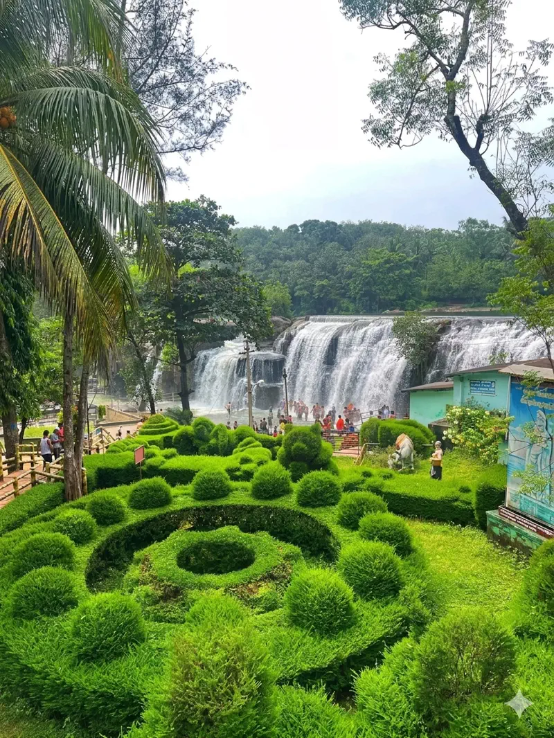
Thirparappu is part of the Kodayar river, not only a bathing place. The river flows over a rocky bed about 300 feet long and drops around 50 feet. Upstream, the Thirparappu weir sends water towards paddy fields. The river supports both visitors and farming.
A Shiva temple stands between the falls and the weir on the left bank. The temple and bathing area have separate entry rules, so follow the instructions for each place.
Look beyond the waterfall
Look upstream at the weir, across the rocks and downstream at the flowing river. These views help explain the whole place. To learn how water is carried across the district, read about Mathur Aqueduct.
Water flow changes with rain and water management. A season that usually has good flow may still not be safe for bathing on the day you visit. Ask the nearby temple directly about its festivals and timings.
Waterfall reservoir and channel
The water seen at a fall belongs to a river system, while storage and diversion structures manage water for other purposes. The irrigation article explains those different roles.
An aqueduct such as Mathur carries a waterway over a valley. Seeing the two places together can make an inland journey more meaningful than comparing their heights.
Three parts of one river scene
At Thirparappu, the rocky upstream bed, the drop and the downstream channel form one connected river scene. A weir upstream diverts water towards cultivation; it does not perform the same job as a large storage dam. Following those three parts makes the place easier to understand than treating the falling water as an isolated attraction.
The district identifies a Shiva temple on the left bank between the weir and the falls. Its enclosure adds a religious history to a landscape already shaped by river flow and agriculture. The shrine is also associated with the wider twelve-temple pilgrimage described in the Sivalaya Ottam feature. A routine waterfall visit and participation in that pilgrimage are different uses of the same locality.
Why a waterfall’s appearance can change
Rain falling across an upstream catchment can reach a river after conditions have changed at the visitor entrance. Reservoir operations and diversion works also affect how water moves through an irrigated landscape. The appearance of the falls is therefore a result of more than the weather directly overhead.
For an inland day, choose whether the priority is the river setting, the nearby temple or time at the bathing facilities. Those activities need different preparation and may have different access arrangements. Mathur Aqueduct makes a useful comparison: Thirparappu displays water descending through a rocky river, while Mathur carries canal water above a valley.
What makes this place unique?
The waterfall, upstream weir and neighbouring shrine reveal how recreation, irrigation and worship share one river setting.
Combine this with nearby places
Thirparappu pairs naturally with Thirunandikkara in the surrounding area. Mathur or Pechiparai needs a separate road leg and its own access check.
Responsible visiting
Stay behind barriers and keep away from slippery edges. Heavy flow is a reason to follow restrictions, not move closer for a photograph.
Quick summary
Thirparappu is best planned around current water and access conditions. Allow 1½–2 hours as an editorial suggestion and treat bathing as conditional.
Sources and further reading
Sources for visitor information and transport
- Kanniyakumari District: Thiruparappu Water Falls — Kodayar waterfall, upstream irrigation weir and nearby Shiva temple. Old listed fees do not establish today's counter rates.
- Kanniyakumari District Administration: Thirparappu Waterfalls — 350 from Kanniyakumari/Vadasery; 89A and 458 from Marthandam; 458 from Kaliyakkavilai, with listed via towns.
- Padmanabhapuram Municipality: Train Schedule and Buses — Official published route endpoints through Thuckalay; no route-table revision date or live service confirmation. Full page retrieved by HTTP on 2026-10-31.
- Southern Railway: Thiruvananthapuram division station list — Station identities/codes NCJ, ERL and KZT only; not a current train timetable, last-mile distance survey or proof of nearest station.
Verification note
Editorial review: . Transport guidance follows the dated source record above; this is not a live timetable confirmation. Current opening hours, fees and permissions have not been independently verified.
Historical references support the research passages they accompany. Editorial visit durations and recommendations are suggestions, not official operating information.