
At a glance
- Location
- Mathur / Mathoor, near Thiruvattar
- Recommended time
- 45–90 minutes
- Best for
- Engineering, valley views and families comfortable around heights.
- Best time
- Choose dry conditions and a cooler visiting hour. Avoid the elevated route during thunderstorms, strong wind or slippery conditions.
- Entry
- Check the current visitor route, ticket and access restrictions. Visitor information should be confirmed before travelling.
- Walking
- The elevated route may feel exposed and involve steps or uneven approaches. Visitors uneasy with heights can choose a permitted ground-level view.
Before you go: Stay on the visitor walkway, hold children's hands and keep away from the water channel.
Visit durations are editorial planning suggestions. Allow extra time for travel, queues and your group’s pace.
Why visit Mathur Aqueduct?
- An elevated irrigation trough across the valley
- The gravity-fed movement of water between slopes
- The relationship between the crossing and the cultivated landscape below
How to reach
By bus
The district lists 89G and 89S from Marthandam bus terminal via Attoor and Thiruvattar for Mathoor Aqueduct. From other starting towns, establish the connection to Marthandam or Thiruvattar before departure. Confirm where to alight and arrange the remaining approach to the visitor entrance. These are official published route listings, not live service confirmations. Confirm the destination board, boarding point, final stop and return service before travel.
By train
Nagercoil Junction (NCJ) is a regional railway gateway; arrange a separate road transfer. Check your train's stopping station and travel-date timetable.
By road
Arrange the final road approach to the Mathoor/Mathur aqueduct entrance in the Thiruvattar area. The bus table does not establish a stop at the walkway gate.
Official route listings checked: . Kanniyakumari District Administration: Mathoor Aqueduct.
Exact drop-off, pedestrian distance, current through-running service, parking and return timetable not verified.
Visitor information
- Published timings
- The district tourism page lists 06:30–18:30. Last verified: 31 October 2026. Confirm the day's route and last access before travelling.
- Tickets and mobility
- Current fees and a step-free visitor route have not been established. Visitor information should be confirmed before travelling.
Best time to visit
Choose dry conditions and a cooler visiting hour. Avoid the elevated route during thunderstorms, strong wind or slippery conditions.
The aqueduct is elevated, with a narrow pedestrian element. Confirm which routes are admitted and whether stairs can be avoided. Visitors uncomfortable with heights can choose an authorised ground-level view instead of attempting the crossing.
Visitor information should be confirmed before travelling. Fees, permissions, facilities and last entry are not established unless explicitly sourced below.
Facilities, parking and accessibility
Confirm toilets, drinking water, parking, step-free access and assistance with the destination. A railway or bus arrival does not establish access to the entrance; plan any final walk or transfer for your group.
Earlier visitor notes
Background notes: current arrangements require confirmation. Use the dated official source record for the scope of verified details.
Plan an inland day
Use the places map before adding other stops. Read the Thirparappu guide to plan both places on the same inland trip.
Ask about the current walking route when you arrive. The high walkway and steps may be difficult for some visitors. Follow barriers and local instructions.
What to see and do
- Begin with an authorised view of the valley and piers
- Use the admitted crossing only if it suits the group
- Continue to Thiruvattar rather than rushing between distant district landmarks
Important things to know before visiting
Stay on the visitor walkway, hold children's hands and keep away from the water channel. Never climb barriers for a photograph.
Best way to experience this place
For families, begin from below so everyone can judge the height before deciding whether to walk onto the permitted upper route.
History and story behind the place
A modern part of our history
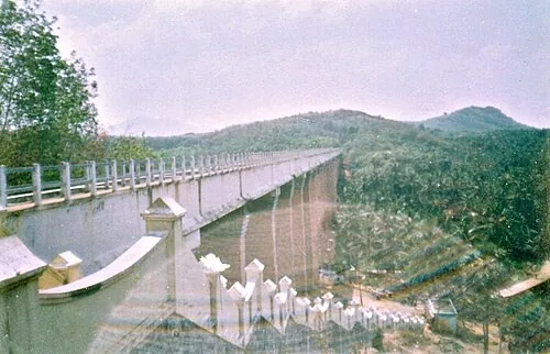
Mathur Aqueduct was built in 1966. Its water channel, or trough, rests on 28 large pillars. The name is also written as Mathoor. It is much newer than the district's palaces and rock-cut monuments.
Modern public works are also part of our heritage. This aqueduct changed how water reached nearby land and farms, so it became part of local life and memory.
Why the aqueduct was built
An aqueduct carries water across low or uneven land. At Mathur, the long raised channel makes this easy to see. Look at how the water enters, crosses the valley and continues on the other side.
Rain alone cannot support farming. Water must also be stored, carried through channels and managed carefully. Read more in Land & Water.
Our pride: Public works like this show the knowledge and hard work behind everyday life.
Three things to notice
- The height: how the raised channel crosses the low valley.
- The pillars: how many pillars support the long channel.
- The view: how villages and farms fit into the valley.
If you visit with children, first ask them what the structure does. Then ask what they notice about its shape and size.
Size and purpose
The aqueduct is about 115 feet high and stands on 28 pillars. The water channel is about 7 feet high and 7 feet 6 inches wide. The height of the whole crossing and the depth of the channel are different measurements.
Water moves through the raised channel while the valley lies below. Unlike a road bridge, this structure was mainly built to carry water across difficult land.
The crossing explained
A trough supported above a valley keeps the canal at a useful level while the river follows the ground below. That is the key distinction in an aqueduct. The drawing shows the principle rather than a measured plan.
The irrigation network puts the crossing into context. Flow, structural height and storage capacity describe different engineering quantities and should not share a comparison scale.
Illustration of the principle, not a measured construction drawing. The trough and the river below are separate waterways.
Read the surrounding valley
Look at the two water routes and the land they cross. Where the public walkway is open, use only the authorised pedestrian route and avoid handling or entering the working waterway.
The palace and Thirparappu can form part of an inland route, with enough time allowed for actual travel and current access.
Read the trough separately from the whole crossing
The district’s engineering table identifies 28 span pillars and a trough approximately 2.286 metres wide and 2.13 metres high. Those are channel dimensions, not the height of the structure above the valley. It also distinguishes the channel’s full-supply water level from the wall above it: that extra vertical margin is called freeboard.
Published summaries differ on overall length and maximum height, even within the district listing. Those values should not be combined into a precise scaled plan. The essential relationship is clear without doing so: piers carry a long water channel, the channel has a gentle longitudinal slope, and a public walking route allows the structure to be experienced at close range where open.
Geography, water and local life
Water and work
Compare Mathur with Thirparappu's river and irrigation weir. At the falls, water drops naturally. At Mathur, people carry water across a valley. Both help farming between the hills and the coast.
The aqueduct does not have a confirmed annual festival calendar. Any celebration at a nearby temple belongs to that temple, not to the aqueduct.
The Pattanamkal canal above the river
The raised trough carries the Pattanamkal irrigation canal. Below it is the river valley, identified under varying spellings of Paraliyar or Pahrali in descriptions of the locality. Two water routes therefore occupy different levels: the natural river follows the valley, while the constructed canal continues towards agricultural land.
A canal needs a suitable gradient along its route. Letting it descend to the valley floor and climb again would interrupt gravity flow. The aqueduct preserves the higher route, with piers supporting the trough between the slopes. Its familiar ‘hanging bridge’ name describes the visitor’s impression of height; the structure’s defining purpose is to carry water.
A 1966 work within a much older water landscape
Mathur’s 1966 construction belongs to the modern extension of the district’s irrigation network. The district describes it as a drought-relief measure benefiting agriculture in the Vilavancode and Kalkulam region. That purpose links the tall structure with less conspicuous channels and the daily work of distributing water.
Pechiparai, Perunchani and Chittar have their own histories of storage. Mathur solves a different problem along a distribution route. The irrigation network explains how the works fit together; this crossing makes one particular engineering solution visible. Its heritage value includes the work of designers, builders and water managers as well as its commanding view.
What makes this place unique?
The structure makes the district's irrigation system visible above the valley: it is a water-carrying aqueduct, not simply a scenic bridge.
Combine this with nearby places
Combine with Thiruvattar Temple on the same inland route. Thirparappu can follow if you allow a separate drive and check water conditions.
Responsible visiting
Keep out of the water trough and do not lean over barriers. Avoid unsupported “highest in Asia” claims when interpreting the site.
Quick summary
Mathur suits an engineering-and-landscape stop. Allow 45–90 minutes as an editorial suggestion and choose the viewing level that feels comfortable.
Sources for visitor information and transport
- Kanniyakumari District: Mathoor Aqueduct — Irrigation trough, piers and published 06:30–18:30 hours; not an accessibility audit.
- Kanniyakumari District Administration: Mathoor Aqueduct — 89G and 89S from Marthandam via Attoor/Thiruvattar; no numbered direct services shown from other terminals.
- Southern Railway: Thiruvananthapuram division station list — Station identities/codes NCJ, ERL and KZT only; not a current train timetable, last-mile distance survey or proof of nearest station.
Verification note
Editorial review: . Transport guidance follows the dated source record above; this is not a live timetable confirmation. Last verified for the explicitly sourced visitor details: 31 October 2026.
Historical references support the research passages they accompany. Editorial visit durations and recommendations are suggestions, not official operating information.